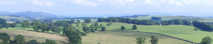
The use of aerial images from a drone can provide many advantages over traditional land surveying. Aerial imaging doesn’t need to be high in the sky either, detailed information can be gathered at low levels too and it is surprising what can be recorded from only 10m or 20m above a site although permissions grant a height of approximately 135m (400′).
Whether your project is a design project or just aerial photography of a house, property or landscape I can be contacted regarding aerial work here.
The advantages for drone useage are numerous and can be tailored to an individual site or project, but briefly they include:
- Having a clear view of a project at that exact moment in time whether it is the first meeting or throughout a project – this is great for monitoring site progress and creating a catalogue of information.
- Seeing everything that exists on a site before design work even begins – this can make a difference to how a design progresses as it can bring up many new discussions and solutions.
- Initial design ideas can be drawn directly onto aerial photographs saving incredible amounts of time in the early stages of design development, this gives much needed clarity as to how a current site is going to be changed and seeing the relationship between old and new.
- Aerial imaging can also capture much more than just overall site images, site details can also be recorded, for instance where drains and services have been installed before trenches are back filled, taking traditional ground measurements and annotating them onto the site images. Perhaps individual areas of planting schemes where individual plants can be plotted onto an image working around existing planting.
- Of course images of a finished project whether it is landscaping or house construction are always great to have. But we can also monitor the site from the air to see how planting schemes are growing or how a site matures over the years after a site is completed.
Understandably as drones are classed as an aircraft we have to follow site safety and complete flight research procedures before taking off, please notify me if you wish to have drone work done as I need to plan ahead with flight research. I can be contacted here.
Prices can be found here.
The use of drones is highly regulated by the Civil Aviation Authority (CAA) who grant Permisson for Commercial Operations (PfCO) upon a strict criteria of training, exams, operations manuals, tests and valid insurance. It is illegal to undertake work without CAA permissions. A list of SUA (drone) operators can be found here.
I hold £1m public liability insurance which complies with Regulation (EC)785/2004 as required by the Civil Aviation Authority.
Terms and conditions for SUA/SUAS (drone) work can be found here (PDF).